Since its creation in 1882, the Observatoire Océanologique de Banyuls (formerly known as Laboratoire Arago) has been constantly monitoring, surveying and recording the continental and marine environment. The data series acquired by the BOSS (Banyuls Observation Sea Service) over the last 20 years constitute one of the longest and most complete databases available in the Mediterranean Sea. The originality of this database lies in the fact that it samples a unique offshore gradient at the exit of the Gulf of Lion under the influence of continental inputs and the general circulation. BOSS is committed to long-term observation of coastal and offshore biogeochemistry in order to understand the natural variability of the ecosystem, the long-term trends that may occur as a result of climate variability and the occurrence of short-term extreme disturbances. The mission is in line with national and international programmes (SOMLIT, OSD, MOOSE, MISTRALS, GOS) that emphasise the importance of maintaining observation networks to understand the effects of climate change and is an essential activity of the Laboratory. The service is currently involved in routine sampling at three observation stations in the Gulf of Lion (Western Mediterranean Sea) along a coast-wide gradient using the Observatory at-sea facilities (R/V Néréis II):
Évolution de la température de surface (°C)
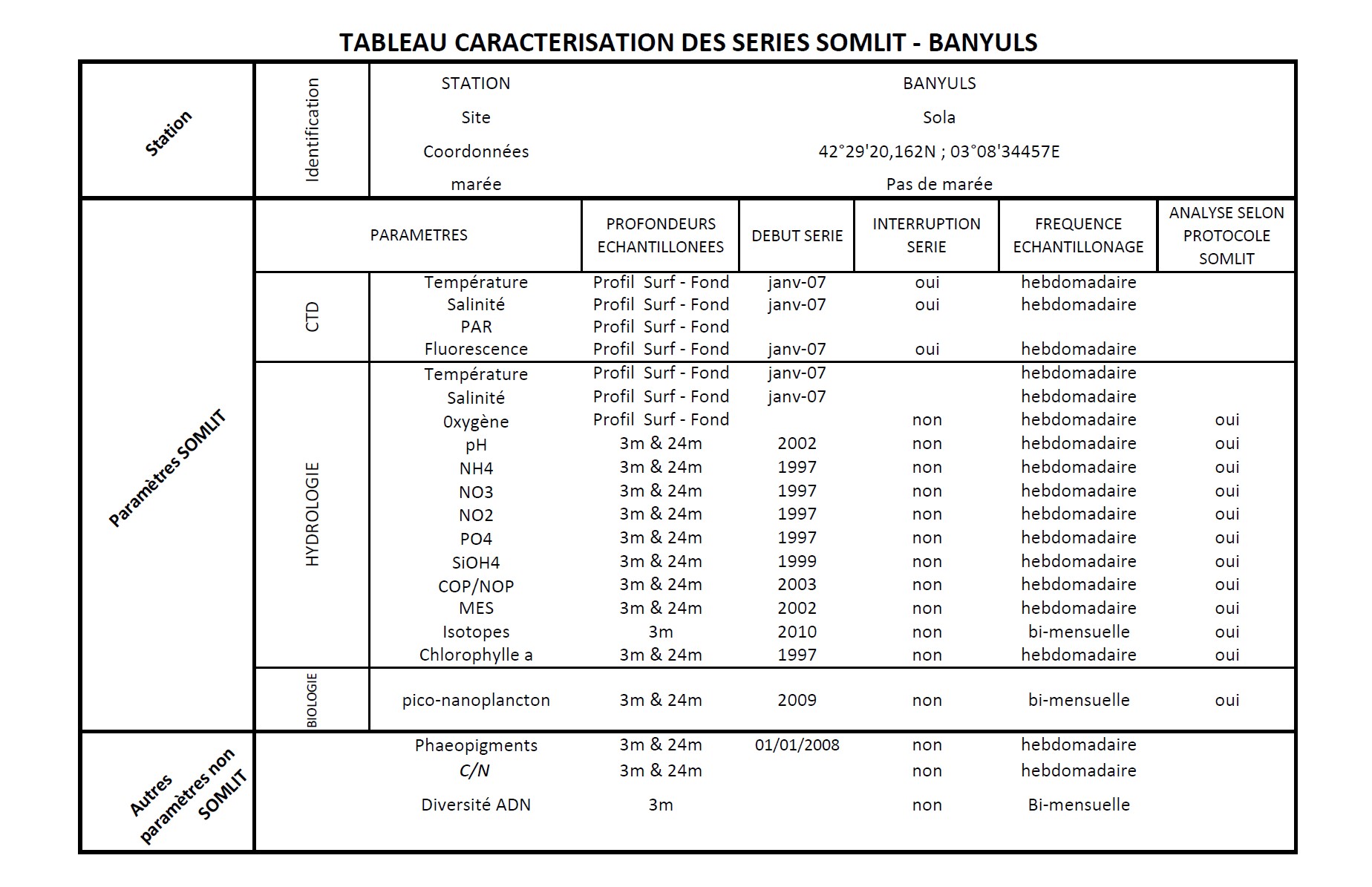
- SOLA station (Service d'Observation du Laboratoire Arago): it is located 0.5 miles from the Observatory (42°29'300 N - 03°08'700 E), above sandy-muddy bottoms at 27m depth. This station is the SOMLIT site; it is monitored weekly since 1997; samples are taken at two depths (surface and bottom) and probe profiles are performed.
- POLA station (Plateau Observatoire Laboratoire Arago): it is located 5 miles off the Observatory (42°28'300 N - 03°15'500 E) above a bottom at about 95m depth. This station is monthly monitored since 2005.
- MOLA station (Microbial Observatory Laboratoire Arago): it is located on the northern flank of the Lacaze-Duthiers Canyon, 19 miles from the coast (42°27.200' N - 03°32.600' E) above a bottom at about 600m depth. This station, identified in the MOOSE network, is monthly monitored since 2003; samples are taken at six different depths and probe profiles are performed.
Évolution de la température de surface (°C)
| Agent | Participation | Prélèvement | Sonde | Analyse | Analyse (description) | Responsabilités | Qualification des données |
|---|---|---|---|---|---|---|---|
| CRISPI Olivier | 10 % | clear | clear | done | Analyses sels nutritifs. Contrôle Qualité. | Responsable Qualité | clear |
| LABATUT Paul | 100 % | done | done | done | Oxygène, MES, Chlorophylle, pH. | Responsable Base de Données | clear |
| MARIA Eric | 100 % | done | done | done | CTD, O2, pH, MES, NH4, S% | clear | |
| MARIE Barbara | 5 % | clear | clear | done | Analyses CHN | clear | |
| PECQUEUR David | 20 % | clear | clear | done | Pico-nano | Responsable Plateforme BIOPIC | done |
| PUJO-PAY Mireille | 5 % | clear | clear | done | Expertise protocoles d'analyses chimiques | done | |
| SALMERON Christophe | 20 % | clear | clear | done | Pico-nano | clear | |
| VUILLEMIN Renaud | 10 % | clear | clear | clear | Coordination | Responsable Service Observation BOSS | done |